Descent: 0 feet (0 m)
Description:
From West Hillsdale Blvd. south to San Mateo city limits, Alameda is a
staircase climb, flattening out at each intersection. Most of the
blocks hover around a 10% grade, but for one short 35-yard stretch,
the grade shoots up to 20%. For a few brief moments, you summon your
strength to persuade the wheels to revolve 16 times, and then the hill
relents.
The heavy traffic is annoying, but Alameda can be useful. A right
turn on Cipriani at the top will take you over a hundred-foot hill to
Ralston Ave, 2/3 of the way up.
Altimeter altitude
(Altitude linearly interpolated from altimeter
samples, and smoothed with a 0.04mi gaussian.)
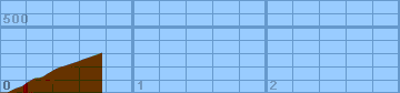
Each horizontal line is 100 feet. Each vertical
line is 0.2 miles. Gradiometer grade
(Grade linearly interpolated from gradiometer
samples, and smoothed with a 0.04mi gaussian.)
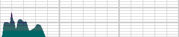
Each horizontal line is 2% grade. Each vertical
line is 0.2 miles. Altimeter grade
(Grade linearly interpolated from altimeter
samples, and smoothed with a 0.20mi gaussian.)
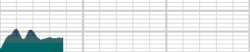
Each horizontal line is 2% grade. Each vertical
line is 0.2 miles. Comparison of grades
(Green grade is from the gradiometer, magenta grade
is from the altimeter, and white is where they
overlap.)
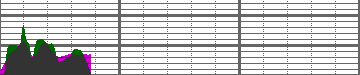
Each horizontal line is 2% grade. Each vertical
line is 0.2 miles.
Overall (averaging my first 20 hills),
the gradiometer grade averages 0.63 (% grade)
higher than the altimeter grade, with a standard
deviation of 4.5 (% grade per road).
This error may be due to:
-
Uneven sampling -- I take more samples when the
hill gets steep.
-
Calibration error (of the gradiometer or
altimeter).
In the end, though, I think that each individual
sample is accurate to within about 2% for that
instantaneous segment of road. My results may
not always agree with my altimeter, but they are
generally repeatable within 1%. I think that
I just need to take more samples to generate
more accurate graphs.
Raw Data:
Dist    Grade   Alti.   Location
----    -----   ------  --------
0.00     0%      120    Hillsdale Blvd
0.04     0%      120    creek crossing
0.05    10%      120
0.11    10%      150    before 36th
0.14    10%      160    3606
0.17     8%      170    3700
0.18    18%      180    3702
0.19    20%      190    3704
0.20    16%      200    3706
0.21    10%      200    3706
0.24    12%      220    3720
0.26     3%      230    3804
0.29    11%      230    39th ave
0.32    12%      240
0.35    12%      260
0.40    10%      290    4004
0.44    11%      310    past fernwood
0.48     4%      320    4028
0.57     6%      350    past 42nd
0.62     9%      370    4216
0.68     8%      390    Belmont city limits
0.76     0%      420    top - Cipriani Blvd.
Back to
Lucas's
cycling gradiometer page.