Descent: 10 feet (3 m)
Description:
The east side of Quinnhill is short, straight, and to the point. It
stays in the 18-19% range for nearly a tenth of a mile.
Altimeter altitude
(Altitude linearly interpolated from altimeter
samples, and smoothed with a 0.04mi gaussian.)
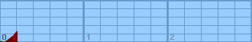
Each horizontal line is 100 feet. Each vertical
line is 0.2 miles. Gradiometer grade
(Grade linearly interpolated from gradiometer
samples, and smoothed with a 0.04mi gaussian.)
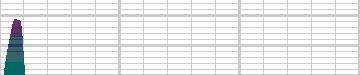
Each horizontal line is 2% grade. Each vertical
line is 0.2 miles. Altimeter grade
(Grade linearly interpolated from altimeter
samples, and smoothed with a 0.20mi gaussian.)
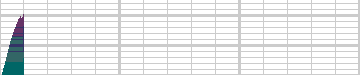
Each horizontal line is 2% grade. Each vertical
line is 0.2 miles. Comparison of grades
(Green grade is from the gradiometer, magenta grade
is from the altimeter, and white is where they
overlap.)
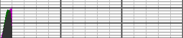
Each horizontal line is 2% grade. Each vertical
line is 0.2 miles.
Overall (averaging my first 20 hills),
the gradiometer grade averages 0.63 (% grade)
higher than the altimeter grade, with a standard
deviation of 4.5 (% grade per road).
This error may be due to:
-
Uneven sampling -- I take more samples when the
hill gets steep.
-
Calibration error (of the gradiometer or
altimeter).
In the end, though, I think that each individual
sample is accurate to within about 2% for that
instantaneous segment of road. My results may
not always agree with my altimeter, but they are
generally repeatable within 1%. I think that
I just need to take more samples to generate
more accurate graphs.
Raw Data:
Dist    Grade   Alti.   Location
----    -----   ------  --------
0.00    -7%     280	start - University Ave
0.05     7%     270	climbing looms ahead
0.11    19%     310	317 Quinnhill - serious, steady climbing
0.16    18%     350	311 Quinnhill - same
0.17    19%     370	309 Quinnhill - same
0.18    18%     380	305 Quinnhill - almost at top
0.20     0%     400	top of hill - La Cuesta
Back to
Lucas's
cycling gradiometer page.